Restoration of the Coonamessett River, Massachusetts

Restoration of the Coonamessett River, Massachusetts

Restoring the Coonamessett River

I’ve done extensive work throughout Massachusetts for the Massachusetts Division of Ecological Restoration, photographing and filming their dam removal and wetland restoration projects. 

This flyover came after photographing the DER’s work in the town of Falmouth at the lower Coonamessett  River watershed. It shows the marsh after dam removal and prior to revegetation, in 2020.

The dead tree stumps you see scattered across the marsh were deliberately left in place to provide shade for frogs, turtles and salamanders. The uneven, bumpy surface of the marsh floor creates diverse habitat for a wider variety of plant life.

As it passes through the preserve, the Coonamessett River is now narrower, longer and has eight new bends. There are now also deep pools for fish to live in and gravel riffles that support insects the fish like to eat.

While the muddy, bumpy, treeless expanse of marsh can be startling to see, what comes next — the growing trees, sprouting seeds, and return of vital habitat — can be seen in the vertical photo of the marsh.


An aerial view of a restored cranberry bog in Massachusetts

Before and after: the Coonamessett restoration after dam and cranberry bog removal.

A vertical aerial photo of a cranberry bog restoration.

Vertical aerial photograph of the Coonamessett (former) cranberry bog area. Two areas are split by a boardwalk: to the left is the marsh before vegetation began to grow.

Aerial photography is almost always recommended for environmental projects, because an overhead view can show you the project in context to the wider surroundings. In most cases, we don’t charge extra for drone photography; a drone is just another camera in our bag.

Allman Environmental Services Photography is at all times FAA Part 107 licensed and amply insured. Let us know how we can help on your next project.


145 NEPERAN ROAD, TARRYTOWN, NY 10591


CONTACT


SERVING ENVIRONMENTAL SERVICE INDUSTRIES, ENGINEERS AND AGENCIES BY USING PHOTOGRAPHY AS A FORCE FOR GOOD.

Qualify Us Now! ProView

The Places We Go: Wadhams

The Places We Go: Wadhams


Wadhams, New York, in Essex County


Funny name, lovely landscape in this out-of-the-way corner of New York State. 

In a tucked-away corner of northern New York State, we delivered progress photography and videography (including aerials) for a water treatment project in Wadhams, a former mill town on the banks of the Boquet River. I’m always happy to do small projects like this one, especially when they lead to old-school or historic places I’d never find by accident. 

Not much there, not even the small-town basics. But the going up there is pretty, ambling along valleys between the Adirondack foothills and Lake Champlain. And if you’re there on any day except Monday and Tuesday, you can stop in at the Dogwood Bread Company — an oasis of conviviality, warm bread and fine cups of coffee.

Allman Environmental Services Photography provides progress photography and videography services (including aerial) to environmental projects of any scale and anywhere in the United States. We love the jobs that are challenging, out of the way or in difficult terrain. We’d love to hear about your project. 

Genesee Valley Greenway

Genesee Valley Greenway


Genesee Valley Greenway

Photography, Videography


The Genesee Valley Greenway is a 90-mile bike-and-hike linear park through the heart of this western New York valley. With photography and videography, we’ll help this fascinating rural trail reach a wider audience. 

This summer, Allman Environmental Services Photography will be photographing and filming the Genesee Valley Greenway for the Friends of the Genesee Valley Greenway’s new website, rack cards and other marketing assets. We’ll spend one week there in late spring, and then again in the fall, when the leaves of the Southern Tier are almost incandescent.

The Greenway venerates the rocky existences of an old canal route and railway, from Rochester to the bottom of the state. Today, it’s a 90-mile long linear park that’s bike-able and hike-able, but also has some more primitive, less-developed sections that are in need of funding. And, to be honest, outside of the Genesee Valley itself, I’m not sure too many people are aware of its existence.

Photography and videography can go a long way toward promoting these tourism assets. But it can also help spur fundraising efforts, grant money acquisition and can serve to get a dubious public the side of a particular project. Show people how beautiful and worthwhile a trail is, and they’ll drive the 100-plus miles to get there. Especially when they’re seeking solitude.

Our directive is to document not just the trail itself (including some places where erosion has made the bank unstable, and drone photographs  help secure funding for streambank improvement), but also the pretty “Trail Towns” that support rural tourism: Scottsville, Geneseo, Avon to the north. Belfast and Cuba, south of Letchworth State Park.

On a personal note, these are the kinds of projects I just love. We shoot a lot of infrastructure projects with heavy documentation needs. But bike trails and greenways are the lighter side of heavy civil projects. Exploration, using every piece of equipment in the trunk, planning for days and days in advance, mapping out routes to places I think will yield the very best photos and video — this is how I love to work. I know the byways of the Genesee Valley won’t disappoint, and I’m looking forward to working that soft warm evening light, the blue highways underneath, long distances between here and there. And summer coming.


Allman Environmental Services Photography provides progress photography and videography services (including aerial) to environmental projects of any scale, in all kinds of weather and geographic conditions. We can accommodate any type of long-distance projects, including greenway, scenic and historic trailways and waterway documentation. We’d love to hear about your project. 

East Side Coastal Resiliency Project

East Side Coastal Resiliency Project


East Side Coastal Resiliency Project


We’re proud to be part of the $1.45-billion dollar East Side Coastal Resiliency project, teaming up with Perfetto Contracting Co. to document this important (and beautiful) flood protection project.

Allman Environmental Services Photography has contracted to perform and deliver the photography and videography requirements of the East Side Coastal Resiliency project in lower Manhattan, a 335-million-dollar project — part of a 1.45 billion dollar plan — and a four-year undertaking that will transform the Greenway.

By any measure, this is a huge job for a photography company. When complete, we will have photographed, printed, bound and delivered approximately 62,000 prints. We will have been on-site for at least 60 days over a four-year period.

But mostly, we’re really interested is this:

The plan…calls for different types of flood prevention: salt-resistant vegetation that can survive flood waters, pop-up sea walls and berms (or earthen walls) that slope down from the sides of the East River bridges within the park. The structure will keep the water at bay when necessary and function as recreation space (or, in the case of the deployable walls, disappear) in nicer weather.”


A total transformation of the East Side Greenway trail and the Avenue C loop.

Gone now are the Asser Levy Playground, the Greenstreets project on Avenue C and — soon — the Murphy Brothers Park at Ave C and 18th Street. But I can’t wait to see what the new playgrounds, ballfields and Greenstreets look like.

Allman Environmental Services Photography provides progress photography and videography services (including aerial) to environmental projects of any scale. All our printing is done in-house, and we can accommodate large-scale printing requirements like those for the East Side Coastal Resiliency project. We’d love to hear about your project. 

Lake Hudsonia Dam

Lake Hudsonia Dam

Last Days of Lake Hudsonia Dam

Aerial view of Lake Hudsonia dam

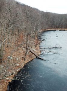
Lake Hudsonia shoreline in winter. ©Suzy Allman/AESP

Another Dam, Too Expensive to Repair, To Come Down

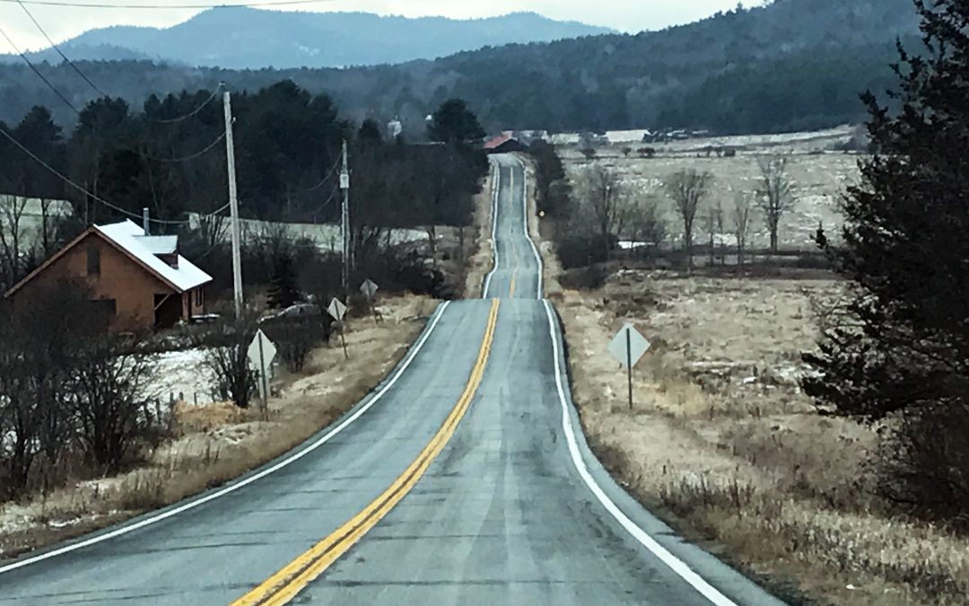
Lake Hudsonia Dam, Dec. 28

This year, I became a dam-removal enthusiast.

I think there are probably a lot of us out there, and our number is growing as dam removal has a “moment”.

Fans of free-running rivers, we like it when old dams come down. We like to see rivers return to their natural course. And, especially, we like the thought of reconnected habitat: of fish, once blocked from spawning upstream, finding a clear path to quiet pools in spring.

I had read that the contract for removing the Lake Hudsonia dam is out for bid. After nearly a decade of discussion, that part of the Hibernia Brook, impeded for decades, will finally run free. I wanted to see what the dam and the lake look like before the structure was removed. And I wanted to make sure to gather “before” pictures, to hold up against the “after”s.

So I took my cameras and headed to Rockaway Township, in New Jersey.

Lake Hudsonia, behind the dam.

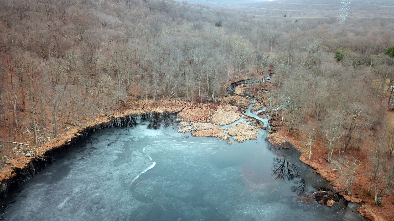
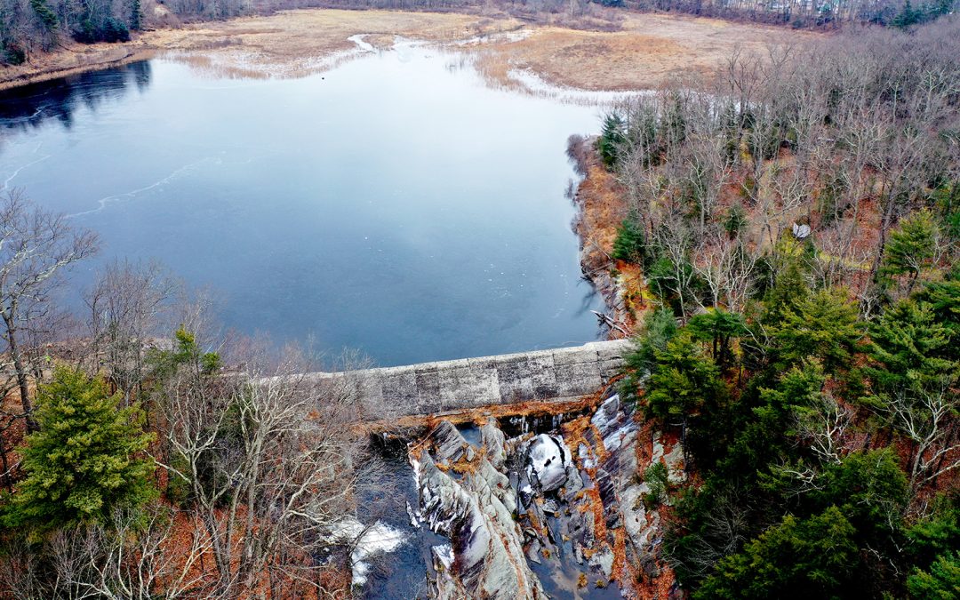
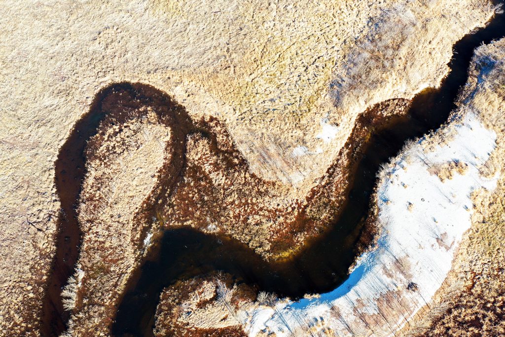
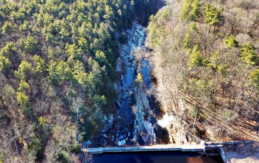
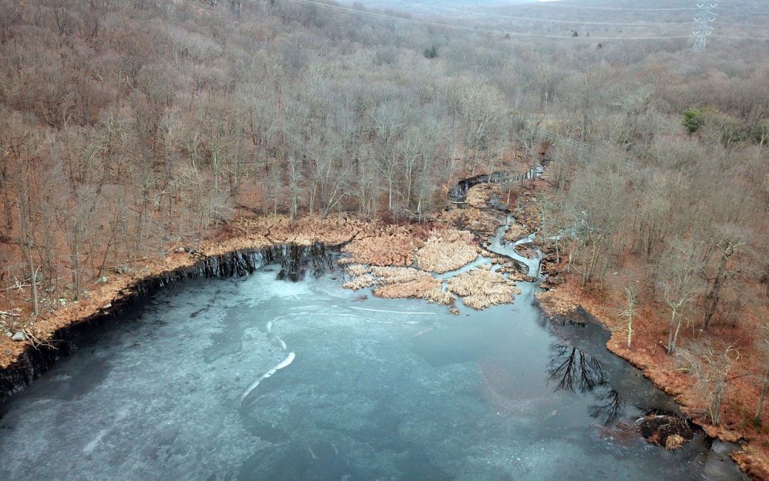
Lake Hudsonia and the drainage area upstream of the dam. Beyond the impoundment — more like a pond than a lake — the Hibernia Brook backs up through a woods. Photo ©Suzy Allman/Allman Environmental Services Photography


The Dam

The dam is located in Rockaway Township, in New Jersey. It impounds a small lake — a pond, really — for about 1.5 square miles.

The lake sits just off Green Pond Road, behind a parking area for a ball field. And it’s a pretty little thing, and no doubt means a lot to the community as a place to fish and watch birds.

Aerial view of Lake Hudsonia dam

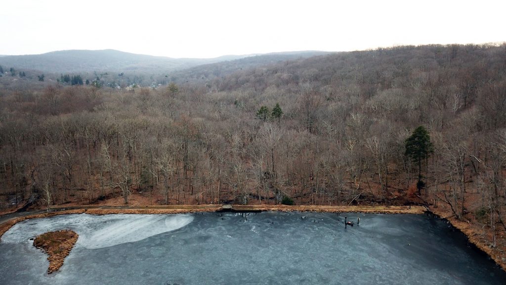
A view of the Lake Hudsonia dam in Rockaway, New Jersey. Photo 2019 ©Suzy Allman/AESP

Holding back the lake is a 500-feet long earth and stone dam, varying in height from 4 to 13 feet. It has a grassy top with a pathway worn by the feet of fishermen and dog walkers.

The spillway creates a waterfall that tumbles into the boggy, wooded acreage in front of the dam. That area is littered with cans, beer bottles, wrappers, and the usual fishing trash (hooks, lines, sinkers, and their packaging).

There are dams just like it all over the country, and so many in the northeast. They once created mill ponds, or livestock ponds, generated electricity, or provided storage for floodwaters. So many of them are “relic” dams today: no longer serving the purpose for which they were built. And many, including the Hudsonia dam, are “high hazard” dams. Fixing — or just maintaining — the aging dam is constantly required. And then there are the increasingly-frequent “100 year” storm events that are hitting the Northeast. The Lake Hudsonia dam sustained notable damage after Hurricane Floyd in 1999, and became a target for the NJDEP Dam Safety Section.

A Place to Fish

When I got there, two men were ice fishing, their tip-ups stationed around the pond but close to the dam.

I wondered if they knew that, by this time next year, the lake they stood on would be a floodplain next to a brook?

Even if they did, I wondered how they felt about it.

Fishing on Lake Hudsonia

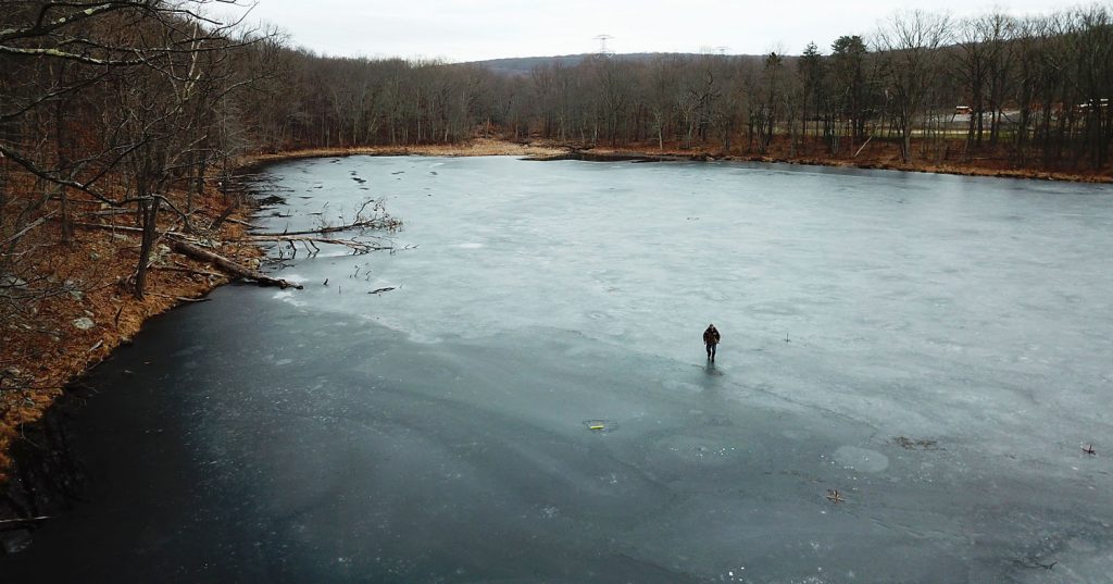
Wintertime fishing on frozen Lake Hudsonia, in Rockaway Township, New Jersey.

It’s always interesting to have conversations with the neighbors of dams slated for removal. Most are against it, and I can understand why.

It’s difficult to lose a lake, a symbol, a historic place, a site of family gatherings or activities, somewhere you’ve seen animals congregate and create homes.

But, my feeling is: our waterways and habitats have given enough to industry in the last century. And it’s time to give something back.

More Pictures of Lake Hudsonia Dam, Before Removal

Pre- (and post-) construction Photography

In the course of my work for the Massachusetts Division of Ecological Restoration, I’ve learned what it means to take preconstruction and post construction photographs of dam removal projects.

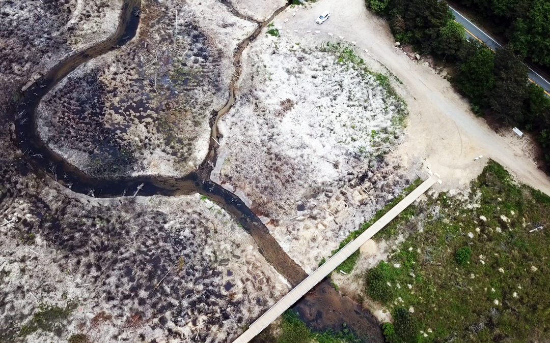
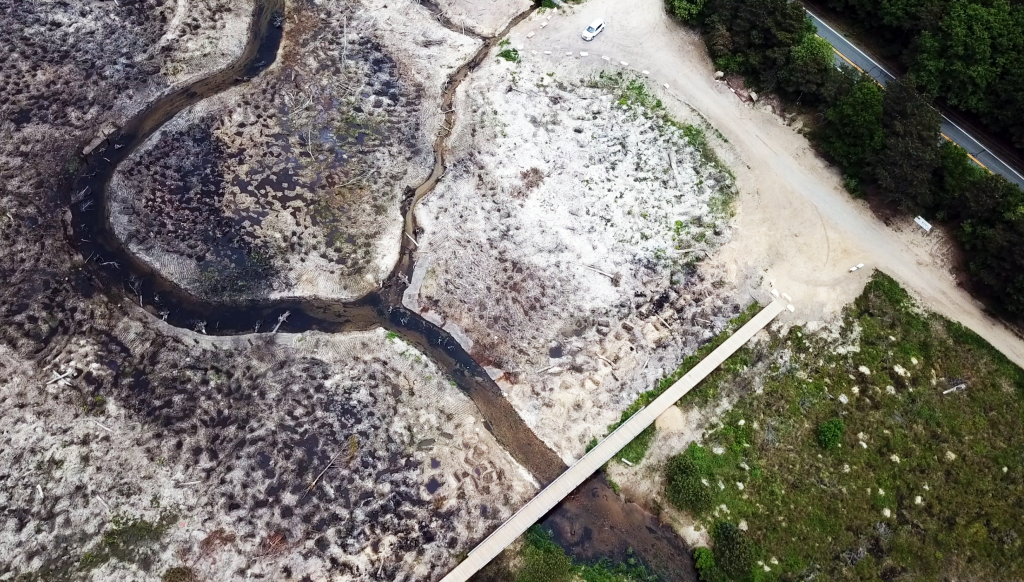
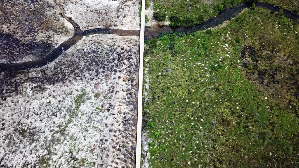
What matters is the change in the river: the creation of a floodplain. The riverbed as it’s scoured back to a natural, rocky state. The path the newly-free river choses, usually on its own (the less man-made interference, the better). Seeds, stored long ago, that hatch into riverside plants.

Because these are the measurable impacts of dam removal.  You can see the difference dam removal makes — not just at the dam site, but upstream, and downstream. The floodplain spreads; rocks show up in the streambed. Rivers just become a little friskier and less sluggish.

And then there are the improvements that you can’t readily see: how the water is delivered to the landscape in pulses, the way it used to be. The way its creatures know and respond to.

And this is the beautiful language of a stream healing itself. For me, there’s no better antidote to the constant drumbeat of environmental degradation than visiting a dam before and after its removal.

Before and after pictures of a dam removal project

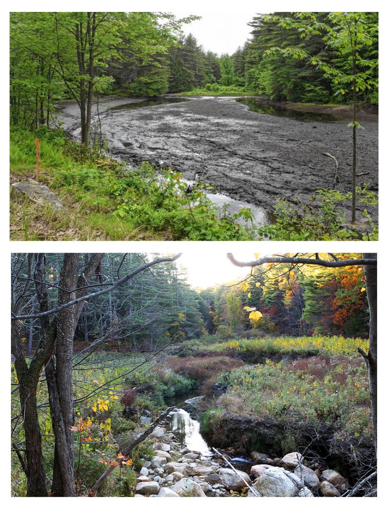
Two photos of the site of the Upper Roberts Meadow dam in Northampton, Massachusetts. The top shows the mud flat that exists after removal of the impoundment; the bottom photo shows the same site, a year later.

A year ago, I was new to this. By now, though, I’ve photographed over twenty dam removal sites this year, from Cape Cod to Pennsylvania, and I can tell you that seeing relic dams come down is uplifting.

I highly recommend it. Find yourself a dam that’s slated for removal (or one that’s already breached). Then watch as the stream, or brook, or river, changes and heals itself. First comes the dewatering, and then the temporary channeling of the brook so the demolition can be carried out. You’ll see an unappealing mat of mud where the pond or lake used to be, but that, too, is temporary.

Watch over a couple of seasons as the floodplain forms, and the river starts to sing the old song: water over rock, frisky and low. It’s astounding, how quickly these changes happen: give it a year. And you’ll never look at a dam again and say, “What a pretty waterfall.”

The spillway of the Lake Hudsonia dam

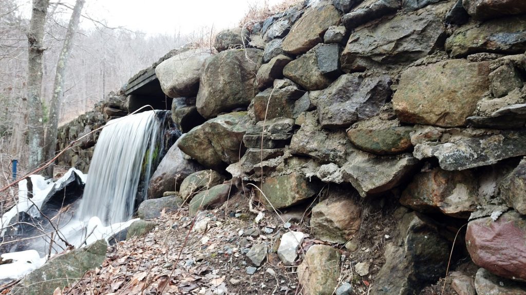
The spillway. The dam is an earth and stone structure reaching 15 feet in some places. Dams change the hydrology of a river; they stop sediment from traveling downstream and change the natural ebb and flow of a waterway, and change the lifecycles of micro-invertebrates and other aquatic creatures. To a spawning fish, a wall is a wall, no matter how tall. ©Suzy Allman/AESP


Allman Environmental Services Photography provides progress photography and videography for environmental infrastructure and construction projects, including dam removal projects and wetland restoration. We love what we do, because we love the projects you do. We are WBE-certified in multiple states in the Northeast.
Contact us about your bid, using the form below, and we’ll get right back to you.

Contact Us

Bidding a project? Just have a message? Get in touch!


5 + 13 =

145 Neperan Road | Tarrytown, New York | 10591 | USA

Fisher Center for the Performing Arts

Fisher Center for the Performing Arts

Bard College’s Fisher Center for the Performing Arts

Annandale-on-Hudson, New York

Nearly a foot of snow had fallen upstate, but the sterling roofline of the Fisher Center was clean for this picture. Curves, scales, fins, and the warm, tangerine light of a Hudson Valley sunset as day made its exit.


Tel-Electric Dam Removal

Tel-Electric Dam Removal

Removal Begins at the Tel-Electric Dam


Pittsfield, Massachusetts

“Don’t forget your waders. The site is contaminated.”

That was the final word of advice for shooting the Tel-Electric Dam, a run-of-river dam in Pittsfield, Massachusetts, for Massachusetts’ Division of Ecological Restoration.

 No problem! But I had to ask what the contamination is behind a dam built beside an electric piano factory. And as it happens, the electric piano factory wasn’t the source of the contamination.

Upstream of the factory, the west branch of the Housatanic River is loaded with PCBs, a legacy of dumping from (oh yes) General Electric. And the Tel-Electric dam served as a trap for sediment containing these PCBs.

In our home state of New York, the lesson was learned in the 1970s: you don’t just tear down a dam with a load of PCBs behind it, lurking in the sediment. In 1973, the Fort Edward dam, which lay below two General Electric factories, was removed, sending thousands of pounds of PCB sediments that had accumulated for years – thanks, GE! — flowing downstream.

Fortunately, the rest of New England learned that lesson as well, and as a result, years of careful planning goes into removing a dam.

In late November of this year, the Tel-Electric dam was breached, and so the on-the-ground work began. SumCo Eco-Contracting is the contractor in these pictures, along with the project designer, Milone & Macbroom.


Environmental services photography is a new branch of construction photography and videography that specializes in the documenting the work of environmental engineers, consultants, contractors, and related fields. Allman Environmental Services Photography is dedciated to documenting the projects that improve the natural world.