Location Matters
Geotagging images for large projects
In large environmental projects, geotagging photographs isn’t just about pinpointing pretty pictures – it’s about harnessing spatial intelligence.
Geotagging Everything.
We geotag our photos in every project we do, whether large or small. Geotagging and Lightroom’s Map feature have become an indispensable part of our editing process.
Using special Canon cameras capable of recording both GPS and direction of view, we tag each photograph, as it’s made, with its location.
With a geotag, that photo becomes pinpointed on a map, instantly linking it to its exact location. We can then return to the same spot, months or years later.

A key plan for a dam removal project in the Catskill Mountains of New York. Red arrows show direction of view and location on a map.
In the editing process, these photographs are plotted on a map in Lightroom.
Each tagged image becomes a data point, weaving a tapestry of progress, change, and impact. This empowers our clients to track deforestation across regions, to see the change over time of a particular slice of river after dam removal, to map the spread of invasive species, or precisely monitor habitat restoration efforts.
It also bolsters transparency, allowing project owners to virtually visit project sites and verify progress. Geotagged photos can be dropped into Autocad drawings, becoming an embedded part of progress documentation and reference.
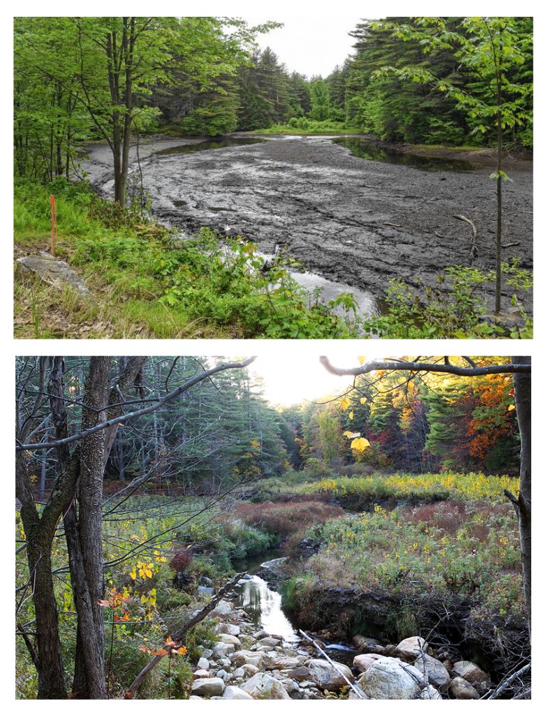
Two photos of the site of the Upper Roberts Meadow dam. The top shows the mud flat that exists after removal of the impoundment; the bottom photo shows the same site, a year later. Tagging photographs with a georeference allows us to return to the same location, months or years later. These photos were taken from the same location a year apart, and clearly show a stream’s progress toward health, after dam removal. A generous, long-dormant regrowth from seed stock can be seen in the later picture.
Using Lightroom’s Map Feature
We use Lightroom’s map feature to:
- Visualize data geographically: By overlaying photo locations on a map, you can instantly grasp the spatial distribution of a project or environmental phenomena, like pollution sources, deforestation areas, or wildlife habitats. This visual representation aids in identifying patterns, trends, and potential areas of concern.
- Connect photos to real-world context: Embedding photos within their geographical context enriches storytelling and data analysis. Viewers can easily understand where each photo was taken, enhancing the impact of visual evidence in environmental reports or presentations.
- Track changes over time: By revisiting the same locations and capturing photos over time, our clients can show progress on a large project, monitor the effectiveness of environmental interventions or document the progression of environmental issues.

Geotagging for smaller projects works the same way. Here, we’ve geotagged and mapped photographs along a dock in Lake Champlain for the Champlain-Hudson Power Express project.
______________
If it’s outside, we’re in! We offer the quickest turnaround on photo and video submissions, contract paperwork and insurance documents, and we’re 100% reliable, flexible and on time, every time. We’d love to work on your next contract. -Suzanne
- CERTIFIED: SBA-certified WOSB, New York State- and City-certified WBE, and Port Authority certified DBE
- REGISTERED: SAM & ORCA. Experienced in Federal Government contracting and subcontracting.
- WILDLAND FIREFIGHTING CERTIFICATES S-130/190, L-180
- FAA PART 107 Since 2017
- OSHA 30 AND HAZWOP certified
- DUNS: 839898728.
- FEIN: 84-2603642
- We accept all government agency purchase orders and credit cards.
SERVING ENVIRONMENTAL SERVICE INDUSTRIES, ENGINEERS AND AGENCIES BY USING PHOTOGRAPHY AS A FORCE FOR GOOD.